Property Record
501 Charlie Davis Rd, Alto, GA 30510
NEARBY LISTINGS FOR SALE OR LEASE
-
-
View all Alto listings for sale on LoopNet.com
Property Detail
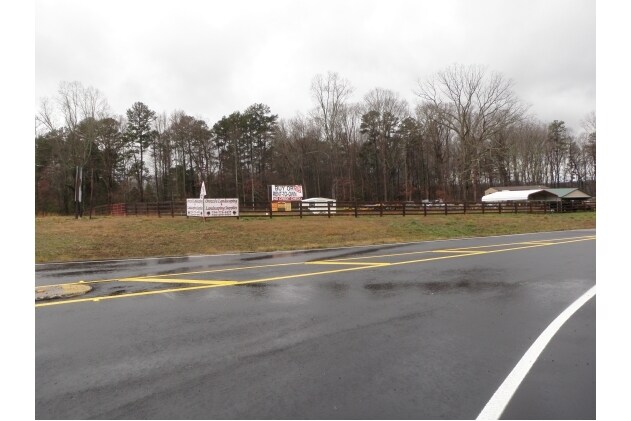
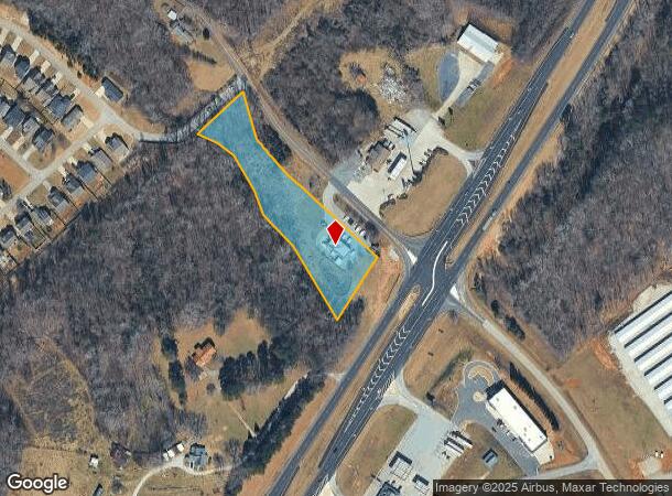
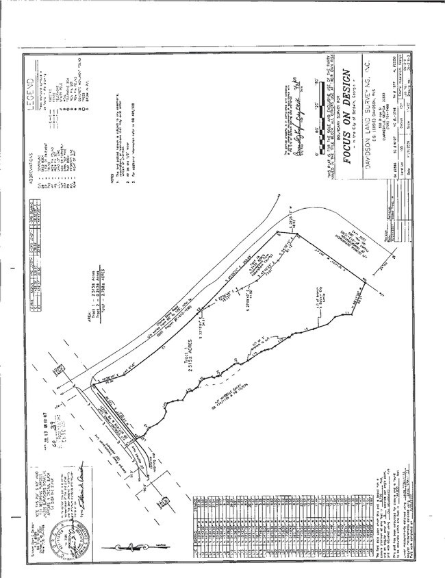
501 Charlie Davis Rd
052-002
10-154 155 PB60-39 1040-674
Restaurantbuilding
Habersham
X
Georgia
13137C0277D
2.76 AC
2025
Georgia Northeast
2025
Other Market Areas
000601
Cornelia, GA
2,138 SF
DEMOGRAPHICS near 501 Charlie Davis Rd
1 Mile
3 Mile
5 Mile
2024 Total Population
1,215
10,378
24,024
2029 Population
1,347
11,455
26,549
Pop Growth 2024-2029
+ 10.86%
+ 10.38%
+ 10.51%
Average Age
39
38
38
2024 Total Households
435
3,291
8,035
HH Growth 2024-2029
+ 10.57%
+ 10.48%
+ 10.55%
Median Household Inc
$61,106
$51,221
$52,297
Avg Household Size
2.80
2.80
2.70
2024 Avg HH Vehicles
2.00
2.00
2.00
Median Home Value
$144,444
$145,138
$159,650
Median Year Built
1995
1992
1991
Nearby Places
Map Layers
Map Styles
 Street
 Aerial
- Restaurants
- Banks
- Shops
- Fitness
- Groceries
Nearby Properties
Address
Land Use
TOTAL SIZE
Lot Size
Zoning
Address
Land Use
TOTAL SIZE
Lot Size
Zoning
88,728 SF
37.73 AC
LI
Address
Land Use
TOTAL SIZE
Lot Size
Zoning
195,516 SF
19.95 AC
B2
Address
Land Use
TOTAL SIZE
Lot Size
Zoning
75,612 SF
29.13 AC
LI
Address
Land Use
TOTAL SIZE
Lot Size
Zoning
21,000 SF
28.32 AC
ARR
Address
Land Use
TOTAL SIZE
Lot Size
Zoning
11,776 SF
34.53 AC
HI
Address
Land Use
TOTAL SIZE
Lot Size
Zoning
119,632 SF
7.49 AC
HB
Address
Land Use
TOTAL SIZE
Lot Size
Zoning
451,247 SF
98.29 AC
M1
Address
Land Use
TOTAL SIZE
Lot Size
Zoning
119,181 SF
12.98 AC
HI
Address
Land Use
TOTAL SIZE
Lot Size
Zoning
152,186 SF
19.81 AC
HI
Address
Land Use
TOTAL SIZE
Lot Size
Zoning
161,855 SF
26.12 AC
HI
Address
Land Use
TOTAL SIZE
Lot Size
Zoning
75,762 SF
9.98 AC
R2
Address
Land Use
TOTAL SIZE
Lot Size
Zoning
53,453 SF
27.79 AC
R1
Address
Land Use
TOTAL SIZE
Lot Size
Zoning
13,072 SF
5 AC
Address
Land Use
TOTAL SIZE
Lot Size
Zoning
35,874 SF
4 AC
HI
Address
Land Use
TOTAL SIZE
Lot Size
Zoning
74,565 SF
7.80 AC
HB
Address
Land Use
TOTAL SIZE
Lot Size
Zoning
4,296 SF
5 AC
R111
Address
Land Use
TOTAL SIZE
Lot Size
Zoning
8,235 SF
5.01 AC
HB
Address
Land Use
TOTAL SIZE
Lot Size
Zoning
45,064 SF
27.23 AC
HB
Address
Land Use
TOTAL SIZE
Lot Size
Zoning
137,296 SF
23.65 AC
I
Address
Land Use
TOTAL SIZE
Lot Size
Zoning
58,572 SF
5.83 AC
B2
Address
Land Use
TOTAL SIZE
Lot Size
Zoning
53,089 SF
15.21 AC
HB
Address
Land Use
TOTAL SIZE
Lot Size
Zoning
35,720 SF
7.75 AC
HI
Address
Land Use
TOTAL SIZE
Lot Size
Zoning
82,942 SF
7.79 AC
HI
Address
Land Use
TOTAL SIZE
Lot Size
Zoning
67.20 AC
LI
Address
Land Use
TOTAL SIZE
Lot Size
Zoning
90,350 SF
19.31 AC
HB
Address
Land Use
TOTAL SIZE
Lot Size
Zoning
74,070 SF
7.82 AC
HI
Address
Land Use
TOTAL SIZE
Lot Size
Zoning
5,602 SF
2.26 AC
B2
Address
Land Use
TOTAL SIZE
Lot Size
Zoning
44,667 SF
2.91 AC
R1
Address
Land Use
TOTAL SIZE
Lot Size
Zoning
54,000 SF
9.75 AC
HI
Address
Land Use
TOTAL SIZE
Lot Size
Zoning
39,840 SF
3.77 AC
HI
The World's #1 Commercial Real Estate Marketplace
Connect with us
© 2025 CoStar Group
The information above has been obtained from sources believed reliable. While we do not doubt its accuracy we have not verified it and make no guarantee, warranty or representation about it. It is your responsibility to independently confirm its accuracy and completeness. Any projections, opinions, assumptions, or estimates used are for example only and do not represent the current or future performance of the property. The value of this transaction to you depends on tax and other factors which should be evaluated by your tax, financial, and legal advisors. You and your advisors should conduct a careful, independent investigation of the property to determine to your satisfaction the suitability of the property for your needs.